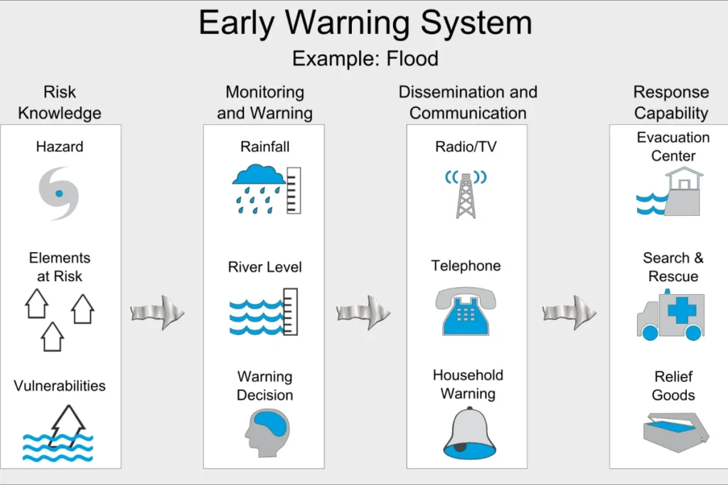
Define Flood Monitoring Warning System
Overview of Flood Warning Systems
Heavy rain, melting snow, and high water can cause flooding. This flooding is a constant threat to life. It disrupts cities and puts community safety at risk. Low areas or places near rivers and lakes are especially at risk for these events.
To reduce these dangers, it is important to set up flood events warning systems near big rivers. These systems help communities and transport networks get ready for floods. They save lives and protect property with quick and accurate warnings.
People around the world pay close attention to flood warning systems. In 1854, France set up the first flood warning system along the Seine River.
The United States improved flood risk control on the Mississippi River in 1966. They used remote sensing tools to collect and study data. Today, many developed countries use automated flood warning systems on different rivers. Some developing nations have also set up similar systems in certain areas.
What is a Flood Warning System?
Engineers build a warning system to manage flood risks. This system checks water levels and warns authorities about changes. It helps lessen damage to property from bad weather.
It also improves our water emergency management.
The system gathers, sends, processes, and analyzes data on water levels. This helps predict floods accurately.
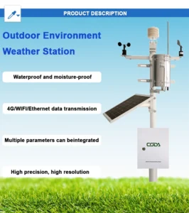
Advanced technology drives these systems. They use IoT, sensors, databases, communication tools, and computer programs. Monitoring rainfall and water levels in real-time helps cut down property damage. It also saves lives by providing early warnings about possible areal flooding will occur.
Key parts of systems that watch for floods in real-time are:
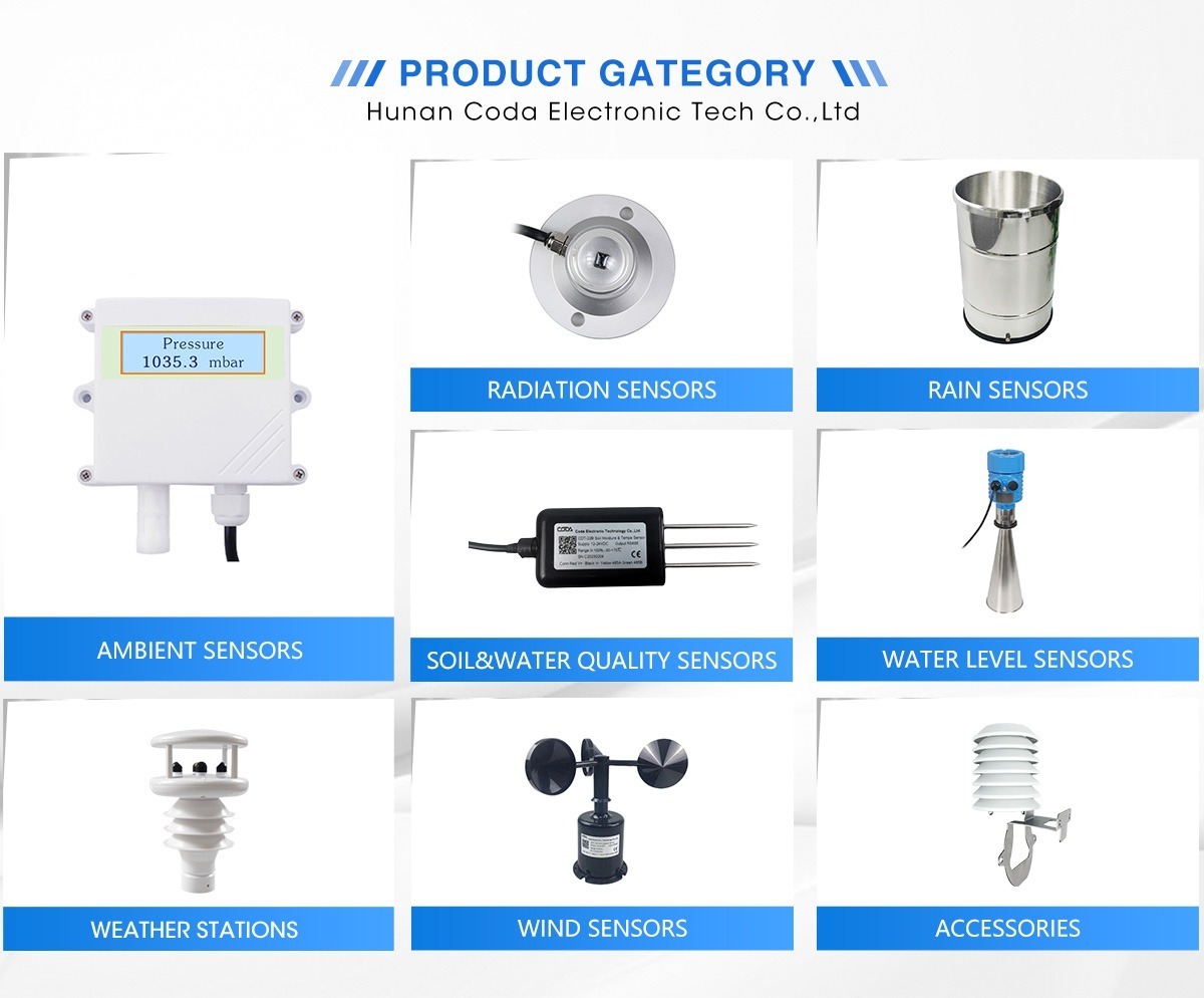
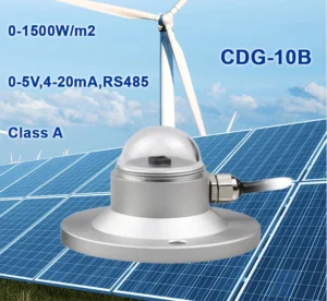
– **Sensors**: Liquid level sensors and weather sensors to gather data.
– **Communication Equipment**: Devices that send data, either wired or wireless.
– **Data Processing Tools**: Software used to collect, store, manage, and analyze information about floods.
Key Types of Flood Warning Systems
1. **Road Flood Warning System**
The national weather service uses water sensors to track groundwater levels in low-lying urban areas. When water levels go too high, the system sends out alerts. This lets staff know to fix drainage issues. It also warns pedestrians and drivers about dangerous water depths.
**Functions and Benefits**:
– Checks for water buildup in places like underpasses, bridges, tunnels, intersections, and overpasses.
– It keeps pedestrians and drivers safe by sending real-time alerts through connected stations.
– Helps with urban drainage by giving accurate data for managing waterlogging in the city.
**Applications**:
– These systems are set up in places like irrigation canals, rivers, drainage outlets, underground garages, and public transport hubs. This keeps people safe and protects property during bad weather.
**System Components**:
The road flood advisory is issued monitoring station typically involves:
– **Sensors**: LORA-based buried water sensors and rain gauges.
– **Infrastructure**: Main stations with LED screens, alarms, telemetry tools, waterproof cases, and support structures like poles.
– **Cloud Platform**: A main platform for watching the environment. It helps combine data and make decisions.
**LORA Buried Water Sensor**
This advanced measuring unit has a strong 304 stainless steel shell. It includes a water level flood detection module to check water depth and status. It also has a Bluetooth module, a LORA wireless communication module, and a rechargeable lithium battery.
Using liquid-based ultrasonic sensor technology, it measures how long ultrasonic waves take to go from sending to receiving. The system measures sound speed and time differences. It looks at how long it takes for sound waves to hit the water and for someone to hear the echoes. This helps the system accurately find the liquid level at set measuring points.
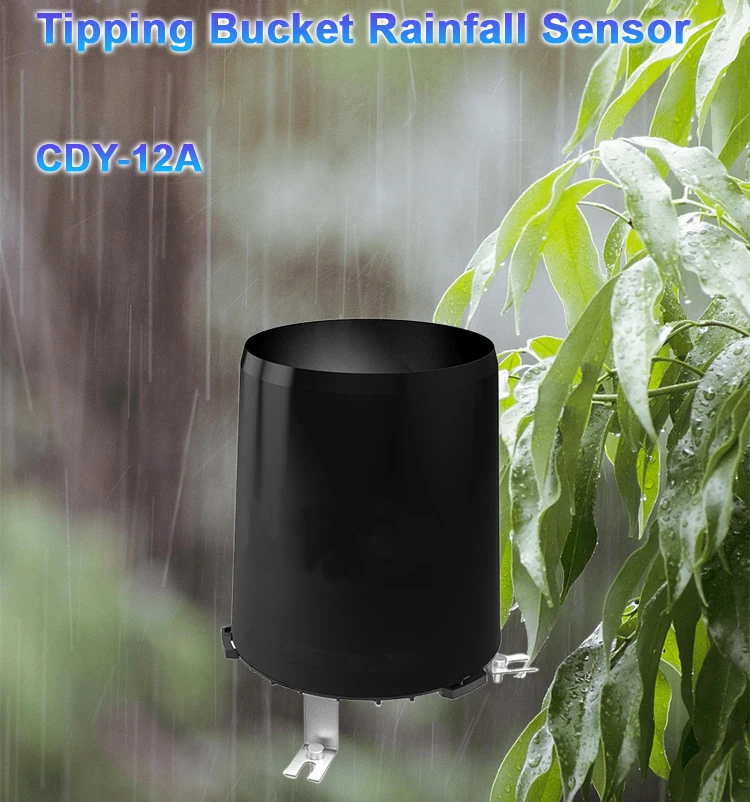
**Rain Gauge**
The tipping bucket rain gauge is a common tool in flood monitoring stations. It is known for its accurate measurements and simple installation.
Engineers create it for outdoor use over a long time. Installers often put it in open spaces to measure rainfall clearly. This device gathers rainfall data from the environment. It provides important help for global flood warning systems.
**LCD Display Screen**
This screen has a 102cm x 22cm LED display. It shows two colors: red and green.
The display has a dot matrix of 16 x 96, set up vertically. This design makes it easier to see in tunnels, highways, and similar areas. It helps people and vehicles see how deep the water is.
2.**Speaker and Alarm System**
The alarm and speaker stay off until the water level goes above set limits. When it exceeds the limit, the speaker plays messages that match the shown data and turns on the alarm. This warning system sends out three alerts every five seconds. It checks again to see if the limit is still too high.
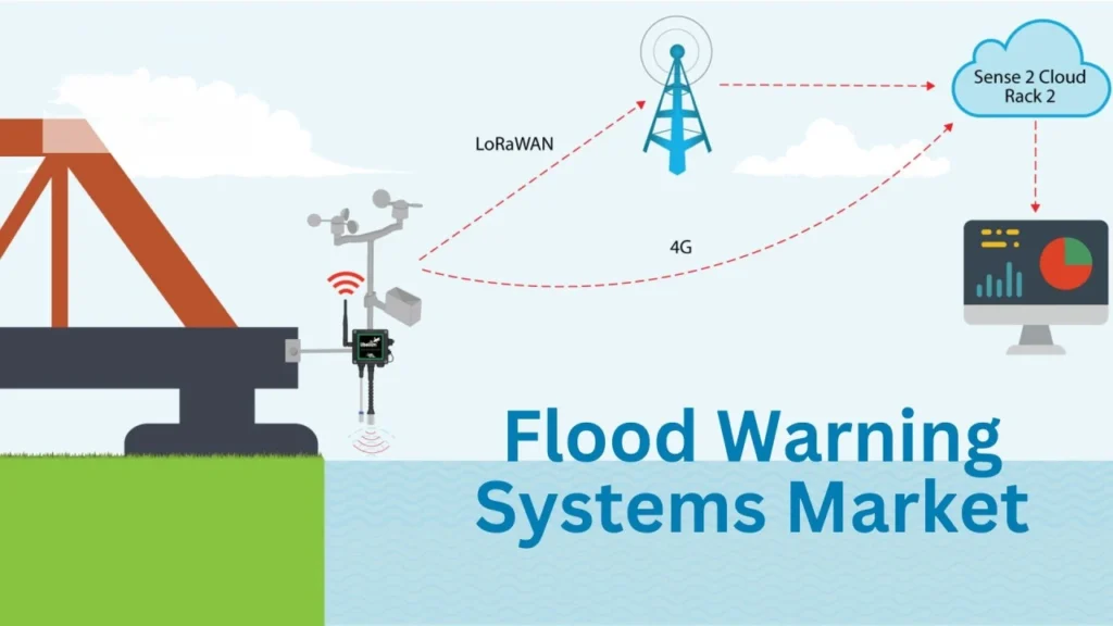
**Telemetry Module**
This telemetry unit is in a waterproof case. It works as a special transfer server. This device allows you to watch things from a distance.
It sends real-time data on water levels and power status. It connects using a 4G module or RJ45.
**Waterproof Box**
The box is made from strong sheet metal. It is covered with a white plastic spray that resists rust. This waterproof box protects against bad weather.
It can handle being outside in rain, snow, and bright sunlight for a long time. The durable housing keeps the inside stable. This helps to keep outdoor performance strong for a long time.
**Pole Structure**
The pole is made of strong stainless steel. It supports other parts.
**Data Platform**
The Flood Monitoring Station has a new system for collecting and managing data. It lets you monitor all day, every day. You can access it through a website.
It helps you see trends in real-time or in graphs. It also lets you control things from a distance and aids in decision-making. The system sends alerts by text or email when data goes beyond set limits.
**Advantages**
1. **Wide Measurement Range:**
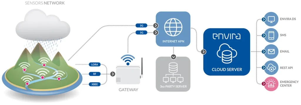
The telemetry unit can connect to 32 water sensors at the same time. This allows data collection from many places in the city. This “one-to-many supervision model” allows for wide coverage of water level monitoring in real-time.
2. **Flood Warnings with Long Transmission Distance:**
Before, checking water levels meant visiting many places in person. LoRa wireless technology allows users to send data up to 1,000 meters without wires. Its strong signal can easily pass through obstacles, ensuring good communication between measuring points and displays.
3. **Simple Bluetooth Configuration:**
You can set up on-site sensors using Bluetooth. Just rotate a magnet three or more times clockwise around the Teflon casing.
The setup software makes it easy for users to connect their devices. It lets them change settings like how often they send data and when they upload it. Users can change the water immersion level and the system time. They can see real-time water level data too.
4. **Remote Data Access:**
Telemetry sends water level data and battery status to the monitoring platform. This lets you access it instantly on your phone or computer.
The platform offers many features. These include real-time monitoring, remote alarms, and historical data export.
Users can change settings, see flood maps, and watch live video feeds. Other features include large screens, user permissions, sharing information, and scheduled controls. These controls can be manual, timed, or automatic.
**Multiple Alarm Methods for Enhanced Safety**
You can set public safety thresholds for water levels on both the sensor and the monitoring platform. If the water at a site goes above the set value, the system will automatically trigger alarms.
– **On-site Alerts**:
The LED two-color display changes its font color to red. It shows the current water level in real-time. At the same time, sound and light alarms alert system nearby pedestrians. Loudspeakers help to prioritize safety.
– **Monitoring Platform Alerts**:
The monitoring interface shows alerts. It uses visual cues like red colors. There are pop-up messages and sound alerts too.
Different channels, such as emails, text messages, or phone calls, send remote alarms. An electronic map shows the exact alarm location. This helps responders act fast and lowers possible losses.
**River Flood Warning System**
This flash flood warning is issued when the system tracks changes in river and water levels. It helps predict possible flood damage. It is built to work well in tough conditions are favorable for flooding.
The system has protective features such as lightning protection and anti-jamming technology. It also includes derating and electromagnetic compatibility. Removing outliers helps make it stronger.
These features help the monitoring station work well in tough environments. They protect lives and property.
**Automatic Flood Warning System**
**System Components**
The river flood is coming or happening. The monitoring station has several important parts:
– **Water Level Staff**:
This device uses a strong processor chip for accurate water level measurements. It has a modular design that lets you adjust settings based on site conditions. The stainless steel casing and special seals make it strong against mud, harmful liquids, dirt, and sediments.
**LED Display**:
Shows real-time water level data and activates when limits exceed.
– **Waterproof Box**:
Houses telemetry and other important electronic parts to keep them safe from outside damage.
– **Solar Panels with Batteries**:
This system is perfect for remote areas without electricity. It runs on solar energy, so there is no need for complex wiring. It can work for up to 7 rainy days on a full charge.
– **Telemetry**:
It sends water level data from the monitoring station to the server. You use a 4G module in a waterproof box to do this.
– **Pole Design**:
It has small holes for internal wiring. This design stops damage from UV rays and animals. An inspection port makes it easy to maintain and set up.
**Optional Camera System**:
You can add a camera to the station. This will help show flash flood is imminent watches and warnings in flood-prone areas. You can send live video to a network for review.
You can find more settings using a cloud platform or a mobile app that connects through Bluetooth. You can change settings like water levels, hysteresis values, delay times, and data upload intervals from far away.
**Real-Time Flood Monitoring Features**
– **Rain Gauge**:
Measures heavy rainfall impact on water level changes.
– **Software Platform**: This makes it simple to link on-site data collection with tools for remote analysis. This helps make quick decisions for preventive measures.
**The Significance of Flood Warning Systems**
Flood monitoring systems are important. They help lessen the harm caused by floods. These stations provide real-time data on rivers, lakes, and reservoirs. They help us act before disasters occur.
Flood monitoring systems provide accurate data and early warnings. They are important tools that help protect lives and property.
The study of how floods form and move depends on real-time weather and water data. This helps predict and prepare for future floods.
It is important for water management teams and emergency responders to know when a flood watch is issued. This helps them prepare for flooding ahead of time.
They need to know when and where it will take place. They also want to know how bad it will be. This knowledge helps them act quickly to protect communities and reduce possible damage.
A real-time flood warning system gives important predictions about when and where floods will happen. These systems help communities act fast and well. They keep people safe and reduce losses.
Good forecasts and smart actions are the best ways to stay safe from floods. They help people and leaders make better choices.
Benefits of Flood Warning Systems
**Precision in Alarms**
Using smart monitoring platforms helps to analyze data and video footage accurately. They do this by taking out climate and environmental factors. This lowers the chance of human error and reduces false positives and negatives in surveillance.
**Real-Time Alerts**
Smart video tools and flood monitoring network technology help measure lakes in real time. The monitoring platform shows alarm notifications quickly and sends them to mobile devices for faster responses.
**Durability for Long-Term Monitoring**
Engineers build flood monitoring systems that work well in bad weather. These systems work well for long outdoor use. They need very little maintenance, which lowers labor costs.
**Data Storage Functionality**
These hydrological models systems track water level changes at monitoring points in real time. They store important alarm data such as timestamps, locations, snapshots, and videos in server databases. This saved information can help with further analysis and improve response planning over time.